20 May 2013 Moore, Oklahoma Tornado Event Case Study
20 May 2013 Moore, OK; EF5 Tornado Event
Begin Cleveland County 2004 UTC 20 May 2013.
End Cleveland County 2035 UTC 20 May 2013.
Oklahoma City, OK radar station. Weather records are for: Fort Sill (Lawton), OK; Chickasha, OK; Duncan, OK; Norman, OK; and Ada, OK.
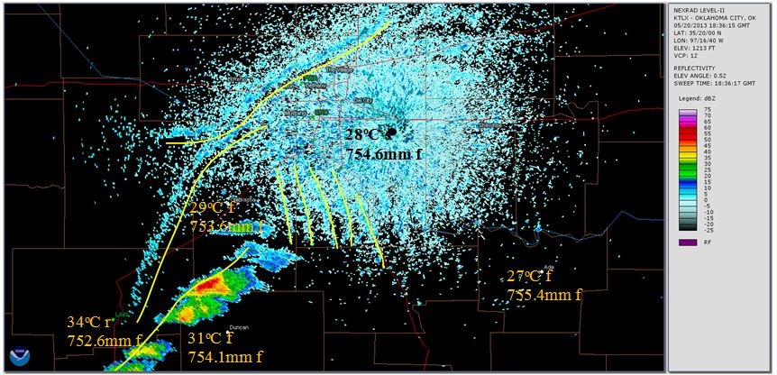
Fig. 17. 1836 UTC 20 May 2013, 88 minutes before the start of the Moore event.
Figure 17 shows conditions southwest of Oklahoma City approximately 1.5 hours prior to the start of the Moore event. Activity includes convection rolls in the Oklahoma City ground clutter zone, two long lines of precipitation moving in from the northwest, and a storm cell to the southwest. The temperature in Chickasha (29oC) is similar to that in Duncan (31oC), indicating that the storm cell has likely divided warm air preceding the cold front. No closure or mesocyclone development is evident.
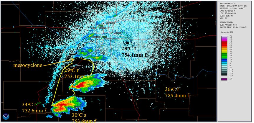
Fig. 18. 1904 UTC 20 May 2013, 60 minutes before the start of the Moore event.
One hour before the Moore event begins; Figure 18 shows the achievement of closure, and an associated mesocyclone hook echo forming north of Chickasha.
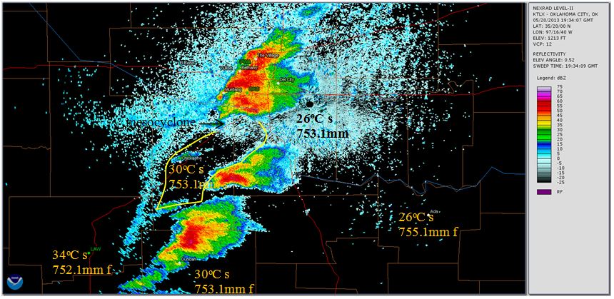
Fig. 19. 1934 UTC 20 May 2013, 30 minutes before the start of the Moore event.
Figure 19, ½ hour prior to touchdown, shows the mesocyclone hook echo continuing to develop, and an island of precipitation activity has appeared within the closure region. As the storm progresses, this activity is consumed by the tornado. Conditions in Chickashaw are steady. The closure region has become well defined; however, its eastern end appears to be the weakest closure boundary. The mesocyclone approaches the Cleveland County line, while the barometric pressure in Norman is fluctuating.
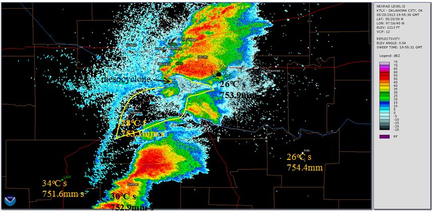
Fig. 20. 1955 UTC 20 May 2013, nine minutes before the start of the Moore event.
Figure 20 shows the island of activity in the closure region approaching the mesocyclone, which has developed a well-defined hook echo. The mesocyclone is crossing over into Cleveland County, approaching the Canadian River Valley. Closure is maintained. The pressure in Norman is at a peak; however, it continues to fluctuate.
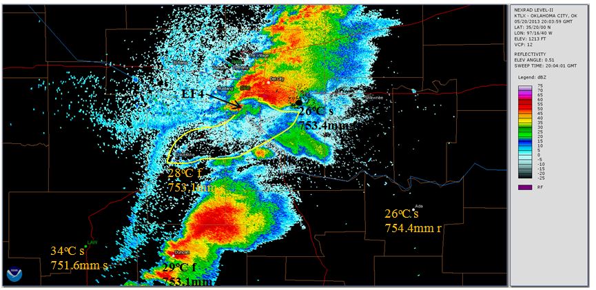
Fig. 21. 2003 UTC 20 May 2013, one minute before the start of the Moore event.
Figure 21 shows the initiating conditions of the Moore tornado. The tornado touches down with an initial EF4 intensity on the west side of the Canadian River Valley. The barometric pressure in Norman continues to fluctuate, and the island of precipitation in the closure region begins entering the tornado, liquid water drawn into the vortex is then blown out aloft.
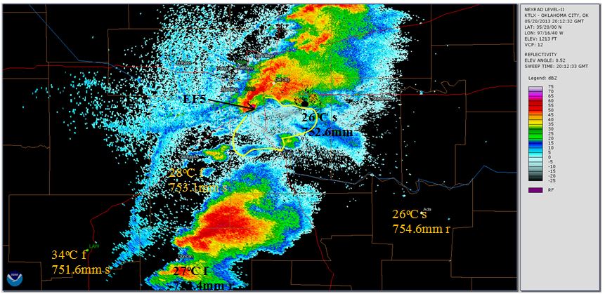
Fig. 22. 2012 UTC 20 May 2013, eight minutes into the Moore event.
Figure 22 shows a transition period, with the closure region filling in on the west by precipitation from the blown out island. This activity is not drawn to the vortex like the island was previously, behaving as a closure boundary, and intensifying pressure. The National Weather Service (NWS) storm survey team rated strength as EF5 in this time frame, with the level of damage sustained by Briarwood Elementary School as a key factor. The tornado signature is in the vicinity of the school coordinates at this time. Thus changes in the closure region appear to have coincided with intensification of the tornado from EF4 to EF5. Note that there is no significant linear echo activity radiating from the region of closure, or the Oklahoma City radar station, in Figure 22.
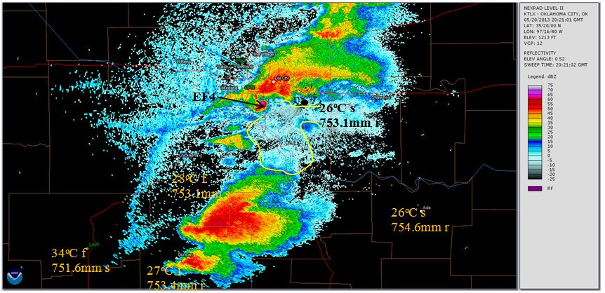
Figure 23. 2021 UTC 20 May 2013, 17 minutes into the Moore event.
Figure 23 shows a considerable reduction in echo density east of the closure region, and the development of linear echoes beyond the closure region is indicative of high velocity air movement and compromised closure. The tornado hook echo is losing definition; however, it still remains active. The NCDC event narrative indicates that the tornado made a loop near the intersection of Telephone Road and 4th Street, adjacent to the west side of Interstate 35, and the NWS storm survey team rated damage as EF4. This is consistent with the location of the tornado signature in Figure 23, with Interstate 35 seen as the red north-south line east of the tornado, thus it is likely that the closure anomalies in this time frame were related to the tornado’s intensity and direction changes.
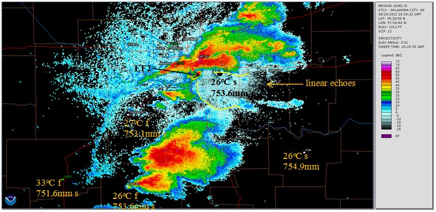
Fig. 24. 2029 UTC 20 May 2013, six minutes before the end of the Moore event.
Figure 24 shows continuing weakness of the closure region to the east. Linear echoes are becoming more pronounced in that area. The tornado hook echo is getting noticeably thinner and less intense. Approaching the end of the event, the tornado intensity was rated EF2, with isolated EF4 damage noted, consistent with closure changes. The negative pressure region’s implosion aloft sustained the tornado at this point.
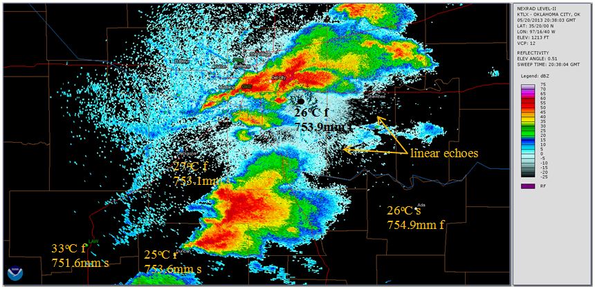
Fig. 25. 2038 UTC 20 May 2013, three minutes after the end of the Moore event.
Figure 25 shows conditions immediately after the event. Significant linear echoes are evident east and southeast of, and aligning with, the ending coordinates of the tornado. Loss of closure over a significant portion of the closure region boundary coincides with the end of the event.
It is likely that high velocity straight line wind events are causally related to tornados. The same pressurization of trapped air occurs; however, the outlet develops laterally through the rain curtain with loss of closure, instead of up a vortex penetrating the cold air above. The debris field is unidirectional, caused by pressurized air escaping in the same general direction as the overall storm. It is reasonable to expect that in some cases the escaping lateral stream of air can be more focused, and thus more destructive, than what occurred over a relatively broad area at the end of the Moore event. However, due to the lack of a negative pressure driver, straight line winds caused by loss of closure are unlikely to achieve the intensity of a tornado.
Back to Case Study Introduction
