Pressurization and Condensation Hypothesis of Tornadogenesis
The family of tornadic phenomena: dust devils, tornados, and water spouts; are fundamentally streams of escaping trapped air. Dust devils occur in low relative humidity environments, tornados in high relative humidity environments, and water spouts in wet environments. The Pressurization and Condensation Hypothesis asserts that the formation of a precipitation curtain that traps a volume of warm air is at the root of all tornadic phenomena.
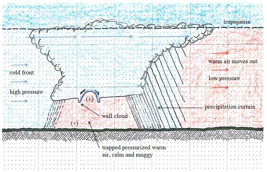
 Fig. 1. High winds aloft draw cold air over warm air.
Figure 1 shows a caricature of the conditions that develop several hours prior to tornadogenesis. A cold front moves in, usually from the northwest, pushing warm air in front of it. High velocity winds aloft draw cold air forward over the warm air below. Lee et al. (2006) shows near-tropopause winds up to 63 ms-1 preceeding the 19 April 1996 Illinois event, with the leading edge wind speed zone that exceeded 45 ms-1 coinciding with the tornado outbreak area in western Illinois. High velocity winds aloft are frequently associated with tornadogenesis in the literature.
 Fig. 2. Precipitation creates a high pressure curtain, perfecting closure.
The next step, illustrated by Figure 2, is precipitation extending to the ground beyond the cold front. Radar frequently shows waves of low intensity activity over a large area, as much as 30-50 km ahead of the cold front. When the precipitation curtain perfects closure, tying back in with the cold front on the flanks, a volume of warm moist air is trapped (hereafter referred to as a closure region). Contained by high pressure, the trapped air is calmed and the cold air column above pressurizes it, which further elevates its relative humidity. Thus the familiar still, muggy tornado precursor conditions develop. The first step of tornadogenesis is closure. Very quickly after closure is perfected the pressure of the trapped air increases enough to invade the cold air mass with a mesocyclone, typically at the back of the trapped air pocket. The frequently reported pendant wall cloud may be initiated by displaced cold air; however, moisture shedding from the rising warm air sustains the wall cloud. The incoming warm air isn’t saturated yet, so the falling water flashes off, intensifying the water vapor load of the rising warm air.
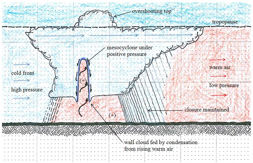
 Fig. 3. Rising pressurized warm air forms a mesocyclone that sheds moisture to begin forming a condensation conduit.
Figure 3 illustrates the mesocyclone stage of tornadogenesis. Pressurized warm air rises through the cold air forming a low velocity mesocyclone. Pressurization lowers the dew point, and the warm air cools as it encounters progressively colder air aloft, thus it sheds moisture at an accelerating rate. The condensation around the mesocyclone is drawn down by gravity, continuing to feed the pendant wall cloud. The lack of a pendant wall cloud associated with a tornado event likely indicates a lower level of relative humidity in the trapped boundary layer.
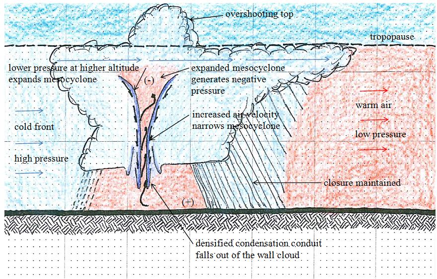
 Fig. 4. Expanding warm air aloft creates a negative pressure region. Escaping air accelerates, the condensation conduit narrows and is drawn to the ground.
Figure 4 shows the final pre-tornadic stage. As the mesocyclone rises through the air column the confining pressure of the surrounding cold air declines, causing the rising air under positive pressure to expand. A tipping point is reached when the expanding warm air generates negative pressure at higher altitudes. The combined positive and negative air pressures accelerate the rate of escaping air to an extreme, causing the condensation conduit to narrow by the Venturi effect, the condensation conduit gets denser, further separating its perimeter from the rising warm air, and accelerating its gravity-induced movement to the ground. Tornado formation approaches as the narrower, heavier, condensation conduit falls out of the wall cloud.
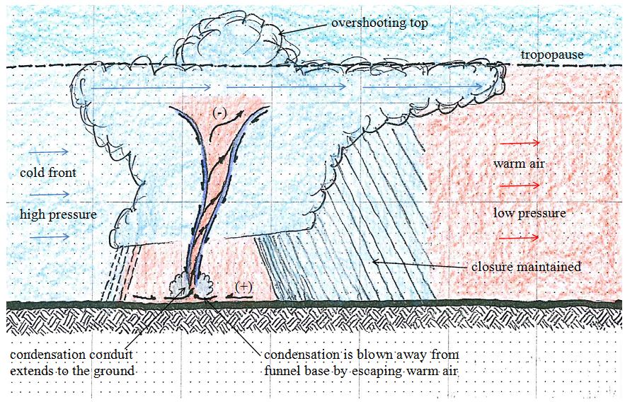
 Fig. 5. A tornado is formed when gravity brings the condensation conduit to the ground.
A tornado (vorticity at the ground) is formed when gravity brings the condensation conduit as close to the ground as it can get before it is blown out by escaping warm air, as illustrated in Figure 5. High relative humidity in the boundary layer increases the probability of tornado development, as noted by Markowski and Richardson (2009), because the added water load promotes the formation of the condensation conduit. The cloud that develops at the base of a mature tornado is falling condensation blown out by the in-rushing air as it approaches the ground. What is herein referred to as a condensation conduit is consistent with the descending reflectivity core (DRC) of Wurman et al. (2012). At this point of tornadogenesis there is too much condensation for the escaping air to absorb. The tornado touches down perpendicular to the ground because gravity draws the condensation coming off of the rising warm air straight down. At mature conditions the stream of escaping air is likely reaching speeds of Mach 1+, generating a rolling sonic shock wave that sounds like a rumbling freight train, and a state of dynamic equilibrium develops.
Once a mature state of dynamic equilibrium is established, as long as closure is maintained, the tornado will continue until the supply of trapped warm air in the closure region is exhausted (e.g. Joplin event). If the rain curtain weakens and closure is lost, the positive pressure at the base of the tornado declines suddenly. This reduces tornado intensity and induces erratic vortex behavior with sudden pressure changes (e.g. Moore event), which is why a tornado cannot be trusted to follow a path. In some cases loss of closure may contribute to the development of another closure region with its own associated vortex. The Dowell and Bluestein (2002) inconclusive study of cyclic tornadogenesis (multiple tornados in a single storm) considers thunderstorm cell mergers and splits, without considering rain curtain activity. A review of radar records from the 2011 Tuscaloosa cyclic tornadogenesis event shows specific closure regions corresponding to all of the tornados.
Despite the loss of the positive pressure driver, a tornado that has lost closure is sustained a short while longer by the negative pressure region aloft. This is analytically consistent with Trapp and Davies-Jones (1997) who indicate qualitatively that a vortex aloft induces a jet below and increased radial inflow at low levels. Without the additional positive pressure from below; however, the falling condensation conduit chokes off the warm air supply in a matter of minutes and the negative pressure region aloft implodes. The Moore tornado ended six minutes after the radar images show loss of closure. Dowell et al. (1997) reported that the COPS-91 Ulysses, Kansas, storm was a dissipating supercell when it was scanned, showing no residual low level vortex only eight minutes after the tornado had dissipated. Further, the airborne observers found that the Ulysses storm lacked an “overshooting” top, leading to speculation that the Ulysses storm top had collapsed by the time Doppler data were collected. This behavior is consistent with a loss of closure leading to the implosion of the negative pressure region aloft and the rapid demise of the tornado.
Conclusion
The Pressurization and Condensation Hypothesis provides a reasonable explanation of tornadogenesis consistent with the fundamentals of classical physics and established natural phenomena. It aligns with documented scientific evidence and old wives’ tales. Further research is warranted to corroborate the hypothesis, which could lead to a more rational explanation of the likelihood of recurrence and a better understanding of how tornados are related to dust devils and water spouts as asserted at the beginning of this article. Research into radar records of past events, and barometric pressure variations within closure regions thus identified, will serve to validate the hypothesis and provide the potential basis for the design of prevention systems. The radar records of the 2011 Tuscaloosa cyclic tornadogenesis event tend to indicate that each closure region had a unique tornado. Perhaps multiple mesocyclones; however, only one tornado. Reports of “twin” tornados runs counter to this and warrant further investigation.
Can high speed, high resolution, photography show that the condensation conduit is also subject to cyclonic behavior, twisting around the rising stream of air within it as it falls to the ground?
Is the reported “freight train” sound really a rolling sonic boom? This phenomenon is regularly reported by survivors; however, published tornadogenesis research does not mention it or provide any speculation as to its cause.
References
Davies-Jones, R., 2004, Growth of Circulation around Supercell Updrafts, J. Atmos. Sci., 61, 2863-2876.
—-, 2006, Tornadogenesis in Supercell Storms – What We Know and What We Don’t Know, Symposium on the Challenges of Severe Convective Storms, Amer. Meteor. Soc.
—-, and Trapp, R.J., 1997, Tornadogenesis with and without a Dynamic Pipe Effect, J. Atmos. Sci., 54, 113-133.
Dowell, D.C., and Bluestein, H.B., 2002, The 8 June 1995 McLean, Texas, Storm. Part I: Observations of Cyclic Tornadogenesis, Mon. Weather Rev. 130, 2626-2648.
—-, and —-, 2002, The 8 June 1995 McLean, Texas, Storm. Part II: Cyclic Tornado Formation, Maintenance, and Dissipation, Mon. Weather Rev. 130, 2649-2670.
—-, —-, Jorgensen, D.P., 1997, Airborne Doppler Radar Analysis of Supercells during COPS-91, Mon. Weather Rev. 125, 365-383.
Lee, B.D., Jewett, B.F., Wilhelmson, R.B., 2006, The 19 April 1996 Illinois Outbreak. Part I: Cell Evolution and Supercell Isolation, Weather and Forecasting, 21, 433-448.
—-, —-, —-, 2006, The 19 April 1996 Illinois Outbreak. Part II: Cell Mergers and Associated Tornado Incidence, Weather and Forecasting, 21, 449-464.
Markowsi, P.M., and Richardson, Y.P., 2009, Tornadogenesis: Our current understanding, forecasting considerations, and questions to guide future research, Atmospheric Research, Elsevier, 93, 3-10.
Wurman, J., Dowell, D., Richardson, Y., Markowski, P., Rasmussen, E., Burgess, D., Wicker, L., Bluestein, H.B., 2012, The Second Verification of the Origins of Rotation in Tornados Experiment, Bull. Amer. Meteor. Soc., August, 1147-1170.
